Successful Cases
Real‑world deployments of our intelligent drone & robotics platform. High‑precision 3D surveys, AI defect detection, and risk‑informed asset management — delivering measurable safety and efficiency gains.
Case Study #1: Pipeline Inspection
Project:Urban Drainage Pipeline 3D Scanning
Technology:Internal robots with multi-sensor systems
Results:
- High-precision 3D models of inner walls
- AI detection of corrosion, cracks, dents, blockages, coating issues
- Risk assessment considering external environment
Outputs
Pipe models, defect maps, risk reports
Advantages
Non-intrusive, comprehensive detection, faster and cheaper, supports repair decisions


Case study #2: Road and Bridge Inspection
Project:Highway Bridge 3D Scanning & Defect Detection
Technology:Drones with visible light, infrared, LiDAR; ground robots for full coverage.
Results:
- High-precision 3D bridge model
- AI-based detection of cracks, spalling, corrosion, exposed reinforcement
- Long-term health archive for monitoring and alerts
Outputs
3D point cloud, mesh model, defects maps, health report
Advantages
Faster inspections, higher accuracy, reduced safety risks, data-driven maintenance planning
Case study #3: Power Line Inspection
Project:Transmission Line & Tower 3D Scanning
Technology:Drones with multi-sensor payloads; robots for tower bases
Results:
- Detailed 3D models of lines, towers, insulators
- AI detection of insulator damage, contamination, tower corrosion, deformation, foundation settlement
- Safety distance analysis with surrounding environment
Outputs
Line and tower models, defect reports, environment analysis
Advantages
Shorter cycles, lower labor cost, no blind spots, early hazard detection, improved reliability


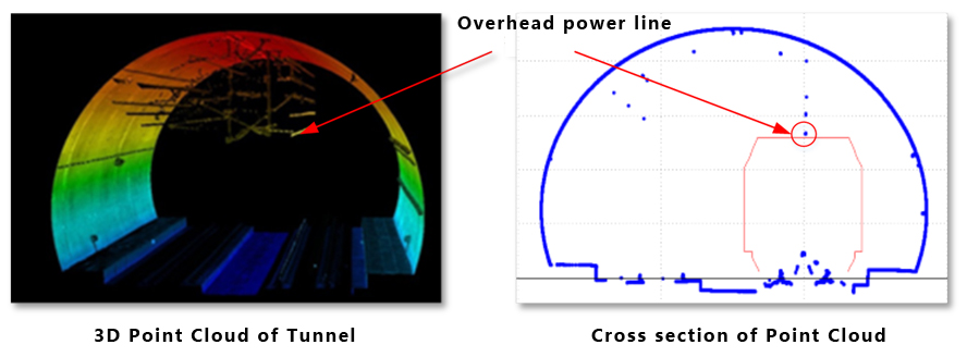
Case Study #4: Road and Rail Tunnel Defect Detection
Project:Railway & Road Tunnel Structural Integrity Inspection
Technology:Drones with LiDAR, thermal imaging, GPR; autonomous robotic crawlers for full coverage.
Results:
- High-resolution 3D tunnel models and lining deformation maps
- AI detection of cracks, water ingress, spalling, exposed rebars, and joint defects
- Automated risk grading and prioritized maintenance alerts
Outputs
3D mesh, defect heatmaps, corrosion analytics, long-term archive
Advantages
Non-stop inspection, enhanced safety, data-driven rehabilitation, early hazard detection
Ready to Transform Your Infrastructure Surveying?
Contact our team to discuss your specific surveying needs and discover how InSurMap can deliver precision data for your critical water infrastructure.